Loiola – La Antigua
This long route begins in Azpeitia, at the Santuario de Loiola – an impressive array of monuments including the sanctuary, all built between the 17th and 18th centuries. At the foot of the limestone hill of Izarraitz, our path leads through the hills of Igarate and Pagotxeta to the hermitage of La Antigua in Zumárraga.
Start: Loiola
Finish: La Antigua
Distance: (15,10 km)
Slope: 835m.
Duration: 4h 00′
MIDE: GR-120 lehen etapa
DESCRIPTION
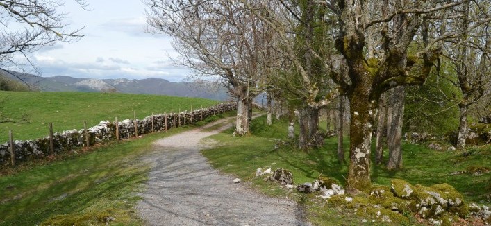
The starting point for this first stage is the Santuario de Loiola. One of the informative panels on this route marks the start of our walk. The walk begins along the tree-lined boulevard of the park beside the monastery. We soon take the turning to the right, which takes us past Casa de la Espiritualidad and Brother Gárate’s family home to the mill at Igara (500 m, 10’).
We continue along the road, bearing left, then taking a right turn onto a tarmac path that becomes steeper and takes us to several country houses. We leave the tarmac surface and continue along a forest track below the Narzabal country house. We pass several more farmhouses and country houses, then pass through an oak and beech wood. After climbing a steep slope we are rewarded with extensive views over Loiola and its surroundings. We quickly enter a pine forest and after crossing several fences we reach the tarmac path that leads to the Garín country house (3.2 Km, 1 h).
Behind Caserío Garín, a cement path guides us to the road, which we leave at the first turning to walk to the Murgil and Kerexeta country houses. We pass by the Haize Leku and Varela estates. Once we pass the crossroads at Kerexeta, Aizpuru and Murgia we reach the Makastegi country house. We continue south to reach the source of the Urtzabal stream, where the track veers towards the east. Continuing among extensive plantations of Insignis Pine we reach Caserío Igarate, a sign of the splendour that once characterised the mansion, though today only ruins bear witness to its glorious past (7.7 Km, 2h 10’).
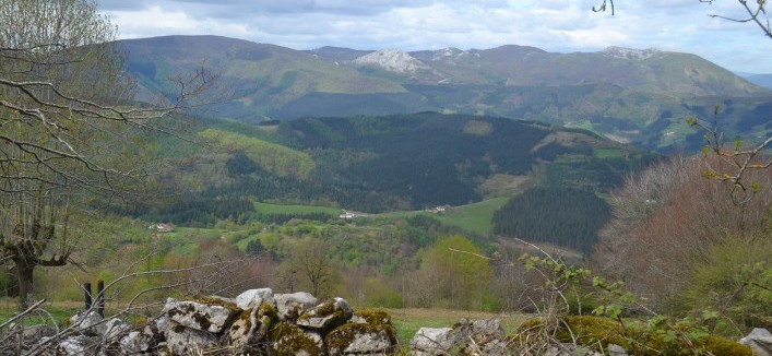
From Igarate we begin the climb to the top of Pagoetxe. We can see circles of natural vegetation surrounded by the extensive plantations we need to cross. The path skirts around the Samiño and Pagola hills and steadily but gradually climbs to reach the top. A chiselled monolith at the crossroads points the way in all directions (San Cristóbal, Izaspi, Los Mártines, Loiola, Samiño)(11Km, 3 h 15’).
From Pagoetxe we begin the descent to Zumárraga along a well-made track through the ubiquitous pine forest. Below the peak of Izazpi we find a new monolith pointing the way in all directions. This is the point where the footpath crosses route GR-34.1 that leads to Mandubia, but we will head towards the Ermita de La Antigua hermitage, now only a short distance away. We skirt around mount Beloki, and reach what was the first parish church of Zumárraga, a clear example of Basque Romanic architecture. (15 Km, 4 h)
La Antigua – Brinkola
Immersed in a rural setting the path rises under the watchful eye of the Argixao and Tralapata hills, and the power of the landscape passes into the hands of the immense forest. The path takes us around Aizaleku and takes us to Santa Marina, a hermitage at the foot of Aztiria. Close to Legazpi the atmosphere seems to be doused in the iron fever of yesteryear and the Parque de Mirandaola pays tribute to this heritage.
Start: La Antigua
Finish: Brinkola
DISTANCE: (16,50 km)
SLOP: 586m.
DURATION: 4h 00′
Malda: 586
Mide: gr_120_2_mide_.pdf
DESCRIPTION
Antioko Baseliza-Brinkola
From the Hermitage of La Antigua a tarmac path takes us down past several turnings leading to different country houses, until we reach the upper part of the San Gregorio barrio (Zumárraga). We walk on, climbing past Antio hiribiea and San Gregorio kalea until we reach the Alto de Eizaga, where we find the Hermitage of Santa Engracia. From the roundabout on the road towards Bergara and Legazpi we climb to the San Isidro neighbourhood, with the huge mount Aralar in the background, and continue along the back of the District Hospital until we emerge from the gate (1.7 m, 30 min.).
From the hospital (Argixao neighbourhood), the path veers to the left towards the Bidaurreta country house in the Elgarresta neighborhood, where a track begins. With a roughly southward direction, the path passes through several villages and reaches the crossroads, where we pass the Oruezabaleta country house on the right. We continue to the left, climbing past several crosses on both sides of the path. Several buildings hidden among trees indicate that we’re arriving in Goiko txabola (2.8 km, 1 h).
Our walk continues around the Zumarragamendi rock formation on the west side, and when we finish our climb we reach the top of Argixao. Towards the east we can recognise the peaks of Usurbe and the range that stretches towards Izaspi. Now on the eastern slopes of mount Trapalaeta, we continue south, arriving at Irazola country house (5.5 km, 1 h 30’).
We take a footpath initially paved with cement, later narrowing and unpaved, which crosses a pine forest dotted with beech trees. The path goes around mount Gaintxiki and takes us to a tarmac path that takes us to Atagoiti country house, on the crossroads with the GI-3540 main road (6.8 km, 1 h 50’).
We are now above the town of Legazpi, and we continue by climbing the slope of mount Aizaleku through plantations of Insignis Pine. After passing the turning towards the peak, a beautiful landscape opens up before us towards the east, in the shape of the valley of Gabiria, the peak of Usurbe and the Sierra de Aralar. The path begins the descent towards Aztiria, cutting through grazing pastures dotted with clusters of pines. Several country houses warn of our arrival in this neighbourhood, whose centre is found a few metres further on at the crossroads with the GI-3520 main road, and signalled by the Hermitage of Santa Marina (9 km, 2 h 20’).
The route descends along a cement path towards the Biurrain country house, and enters a pine forest dotted with grand oak and beech trees. The path climbs gently and enters an area with several footpaths. We take the one that goes downhill after passing a disused hut, into a leafy mixed forest. After crossing a cement path, we take the second turning to the right, which takes us to the GI-3520 main road (12.6 km, 3 h 10’).
We continue west along this road until we cross a bridge, then continue along the track. We leave the track when we reach a turning to the right, and take a path that sometimes can be hard to see for undergrowth. We slowly descend through the dense and varied forest to Mirandaola, after crossing the train line via a narrow tunnel (14.3 km, 3 h 30’).
From the park of Mirandaola the route goes back up the course of the river Urola, passing among the alders that line its banks, towards Telleriarte and its array of country houses. On the way to Brinkola we can find interesting explanations of the historic uses of the river Urola and of the hydraulic projects along its length which were essential to the ironworks (16.5 km, 4 h).
Brinkola – Arantzazu
The route bears testament to the frenetic activity of the ironworks alongside the upper end of the river Urola. After passing the Barrendiola Reservoir our route climbs the mountainsides on the north side of the Sierra de Aizkorri, and enters the Aizkorri-Aratz Natural Park. Once at the top of the Biozkornia the path continues through green pastures that coexist in beautiful harmony with the rocky limestone. The final stage, through a leafy forest, takes us eventually to the Sanctuary at Arantzazu, close to Oñati.
Start: Brinkola
Finish: Arantzazu Monastery
DISTANCE: (10,70 km)
Height difference: 762m.
DURATION: 3h 30′
Mide: GR-120 3 mide
DESCRIPTION
The ruins of the Olazar ironworks mark the start of the Brinkola district. We cross it following the line of the GI-3511 main road, and head towards the Barrendiola Reservoir. We pass by the reservoir water control centre and continue along the road to the dam itself (1.5 km, 25’).
We cross over the dam to the opposite shore, continuing along the track that goes back around the reservoir. We take a turning to the right to climb to the top of Frantzikorta, a foothill of mount Arratola (3.3 km, 45 min), where several forest tracks come together. The route continues upward, levelling out as we arrive at the top of Kortazabal (4.4 km, 1 h 10’).
The track passes through a coniferous forest dotted with oaks of several varieties and the odd beech, taking us to the shepherds’ huts at Jarondo. The track widens and the beech trees dominate the surroundings. The slope gets steeper and we begin to see the ruins of the Katabera mines. The wood is below us now; the rock and the pastures grapple for the upper hand and a broad panoramic view is possible again. The path continues winding up the slopes of mount Arriurdin, and zigzags to the top of Biozkornia, situated between the peaks of Artzanburu and Arriurdin (6.4 km, 2 h).
A nearby signpost marks the way to Arantzazu. Following the line of milestones we pass by a pond, and soon afterwards witness how karst landforms begin to dominate the limestone masses. A fountain beside a small ash grove is a good place to catch your breath, sheltered from the strong winds that are customary on the hilltop. The track continues downward, passing a strange private refuge known as Eskista. The route continues west, until we reach a left fork that enters a wood and takes us to the shepherds’ huts at Nazarionea, Alkorta and Zubillaga. We’ve reached the area of Duru (8 km, 2 h 50’).
There are only a few metres left to go. There’s a steep descent along a track that passes through a heterogeneous forest, emerging at the Humilladero del Santo Christ shrine. A little further on we reach the buildings at Goiko Benta, Milikua and the Sanctuary at Arantzazu, the end point of our pilgrimage (10.7 km, 3 h 30’)